
Trekking in Santa Marta | The Best Routes for Adventurers
Santa Marta is not only known for its history, culture, and idyllic beaches but also for its towering mountains, dense jungles, and trekking routes that challenge both amateurs and experienced adventurers alike. Surrounded by the majestic Sierra Nevada de Santa Marta, the city and its surroundings offer a variety of trails that lead to unique destinations worldwide.
In this article, we present the best hiking routes for those eager to explore the most breathtaking landscapes in this region.
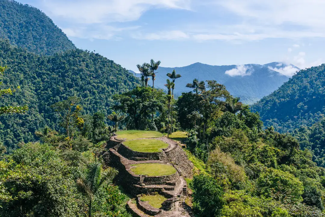
Trekking to Ciudad Perdida
One of the most famous treks in Colombia is the journey to Ciudad Perdida. This ancient indigenous settlement, also known as Teyuna, is nestled deep in the Sierra Nevada de Santa Marta and dates back approximately 650 years before Machu Picchu. The trek to Ciudad Perdida is an immersive experience in both history and nature.
The hike takes between 4 and 5 days, depending on the hikers' pace, covering approximately 47 kilometers round trip. Along the way, you will cross rivers, waterfalls, humid jungles, and steep mountains. Local indigenous guides offer valuable insight into the history of the region and the culture of the native peoples who still inhabit the Sierra.
Route: Machete Pelao (El Mamey) - Camp 1 - Camp 3 - Ciudad Perdida
Difficulty level: High]
Duration: 4 to 5 days
Recommended season: December to March
More information about trekking to Ciudad Perdida here.

Trekking in Tayrona National Park
Tayrona National Natural Park is a must-visit destination for nature lovers. This park offers a unique combination of crystal-clear beaches, mountains, and jungles, making it an ideal spot for hiking. One of the most popular trails leads from Cañaveral to Cabo San Juan, a route that allows you to enjoy spectacular views of the Caribbean Sea and explore the park’s rich flora and fauna.
The hike in Tayrona Park is moderate, with well-marked trails that pass through dense vegetation and pristine beaches.
Route: Cañaveral - Arrecifes - Cabo San Juan
Difficulty level: Moderate
Duration: 2 to 3 hours (one way)
Recommended season: November to April
More information about trekking in Tayrona Park.
-lprvar.webp)
Trekking in Minca
Minca, located 650 meters above sea level and just 14 kilometers from Santa Marta, is an ideal destination for trekking. Surrounded by lush vegetation and boasting a cool climate that contrasts with the coastal heat, it offers stunning landscapes of mountains, waterfalls, and spectacular views of the Sierra Nevada and Santa Marta Bay, making it a popular spot for nature and hiking enthusiasts.
Among the most recommended routes is the hike to the Marinka Waterfalls, which takes about 30 minutes from the village—perfect for those looking for a relaxed experience in the middle of the jungle. For more adventurous hikers, there are routes like the Mirador de Los Pinos, offering panoramic views after a two-hour hike, or the ascent to Cerro San Lorenzo, a more physically demanding and longer trek.
Besides its trails, Minca is known for its organic coffee plantations, where travelers can learn about the cultivation and production process, adding a cultural dimension to the trekking experience.
Route: Minca - Marinka Waterfalls – Los Pinos Viewpoint – San Lorenzo
Difficulty level: Low to moderate
Duration: 1 to 4 hours (depending on the route)
Recommended season: All year round
Explore more about experiences in Minca here.
Trekking to Playa Inca Inca
The trek to Playa Inca Inca, starting from El Rodadero, takes approximately 30 to 40 minutes on foot via a natural trail, depending on the hiker's pace and physical condition. The path features some mild slopes and uneven stretches, so it's recommended to wear appropriate footwear and sunscreen due to direct exposure to the sun at most points. Playa Inca Inca is accessible only by foot or by boat, so those preferring to avoid the walk can opt for maritime transport.
Route: Santa Marta - Playa Inca Inca
Difficulty level: Moderate
Duration: 30-40 minutes
Recommended season: All year round
More information on how to get to Playa Inca Inca.
-qqpvas.jpg)
Trekking to Playa Brava
The trek to Playa Brava, starting from the Calabazo sector in the Tayrona Park, is a hike that takes about 4 hours, depending on the pace and experience of the hiker. The trail passes through dense tropical vegetation, with ascents and descents that can be demanding in some sections. It is important to wear appropriate footwear and bring enough water, as the route is long and there are no hydration points. Playa Brava is an isolated and quiet destination, accessible only on foot, which guarantees a unique experience of disconnection in the middle of nature.
Route: Calabazo - Playa Brava
Difficulty level: Moderate
Duration: 4 hours
Recommended season: December to January
More information on how to get to Playa Brava
Santa Marta offers an incredible variety of trekking routes for all kinds of adventurers, from beginners to experts. With every step, hikers can experience a unique blend of landscapes, history, and culture. Whether you prefer to explore ancient civilizations or simply enjoy ocean views while walking along the coast, Santa Marta has a perfect trail for you. Discover more at www.tumap.travel.

This product has no ratings yet. We invite you to write your first rating
To write a comment you must log in
Login